 https://seagrant.mit.edu/wp-content/uploads/2024/04/Santiago_Unyi_sized.png
1400
2100
Lily Keyes
https://seagrant.mit.edu/wp-content/uploads/2023/05/MITSG_logo_website.png
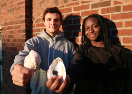
Lily Keyes2024-04-19 10:59:342024-04-19 11:00:51Advancing technology for aquaculture: MIT Sea Grant students apply machine learning to support local aquaculture hatchery
https://seagrant.mit.edu/wp-content/uploads/2024/04/Santiago_Unyi_sized.png
1400
2100
Lily Keyes
https://seagrant.mit.edu/wp-content/uploads/2023/05/MITSG_logo_website.png
Lily Keyes2024-04-19 10:59:342024-04-19 11:00:51Advancing technology for aquaculture: MIT Sea Grant students apply machine learning to support local aquaculture hatcheryWHAT WE DO
The Marine Advisory Services group works with Massachusetts communities on projects involving coastal habitats and the resources and services within their influence. We support sustainable management practices to safeguard coastal habitat resilience, and increase understanding of coastal systems, resource use, and societal impacts through collaborative research and outreach.
WHO WE WORK WITH
- Federal and state agencies
- Cities, towns and municipalities
- Non-governmental organizations
- Citizens and communities
- Educators, students and schools
- Local fisheries
ECOSYSTEM HEALTH
- Reduce coastal pollution, habitat loss, and coastal hazards
- Prevent and track non-native species
- Foster collaboration among regional scientists and managers
- Develop citizen science programs
FISHING COMMUNITIES
- Manage, support, and sustain active and productive fisheries
- Provide safety training and other technical assistance for fishing communities, including managing space-use conflicts in the marine environment
- Design and implement fishing policy social impact assessments
EDUCATION & OUTREACH
- Bring the latest science and technology to students, professionals, and the general public
- Create innovative and hands-on K-12 educational programs
- Provide intensive summer programs and internships for high-schoolers
- Increase ocean science literacy
HIGHLIGHTS | Marine Advisory Services
https://seagrant.mit.edu/wp-content/uploads/2024/04/Santiago_Unyi_sized.png
1400
2100
Lily Keyes
https://seagrant.mit.edu/wp-content/uploads/2023/05/MITSG_logo_website.png
Lily Keyes2024-04-19 10:59:342024-04-19 11:00:51Advancing technology for aquaculture: MIT Sea Grant students apply machine learning to support local aquaculture hatchery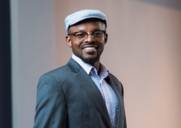 https://seagrant.mit.edu/wp-content/uploads/2024/04/AristideGumyusenge_MITDMSE.jpg
580
1800
Lily Keyes
https://seagrant.mit.edu/wp-content/uploads/2023/05/MITSG_logo_website.png
Lily Keyes2024-04-17 16:46:442024-04-18 16:05:02Welcoming MIT Assistant Professor Aristide Gumyusenge as 2024 Doherty Professor in Ocean Utilization
https://seagrant.mit.edu/wp-content/uploads/2024/04/AristideGumyusenge_MITDMSE.jpg
580
1800
Lily Keyes
https://seagrant.mit.edu/wp-content/uploads/2023/05/MITSG_logo_website.png
Lily Keyes2024-04-17 16:46:442024-04-18 16:05:02Welcoming MIT Assistant Professor Aristide Gumyusenge as 2024 Doherty Professor in Ocean Utilization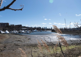 https://seagrant.mit.edu/wp-content/uploads/2024/04/BayStateBanner.jpg
683
1024
Lily Keyes
https://seagrant.mit.edu/wp-content/uploads/2023/05/MITSG_logo_website.png
Lily Keyes2024-04-10 15:19:142024-04-10 15:19:14Coastal Resilience Efforts Cross City Lines at Island End River in Chelsea and Everett (Bay State Banner)
https://seagrant.mit.edu/wp-content/uploads/2024/04/BayStateBanner.jpg
683
1024
Lily Keyes
https://seagrant.mit.edu/wp-content/uploads/2023/05/MITSG_logo_website.png
Lily Keyes2024-04-10 15:19:142024-04-10 15:19:14Coastal Resilience Efforts Cross City Lines at Island End River in Chelsea and Everett (Bay State Banner)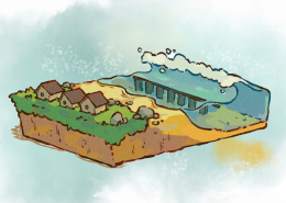 https://seagrant.mit.edu/wp-content/uploads/2024/03/MIT_Architected-Reef-01-PRESS_0.jpg
600
900
Lily Keyes
https://seagrant.mit.edu/wp-content/uploads/2023/05/MITSG_logo_website.png
Lily Keyes2024-03-26 13:03:062024-03-26 13:07:03Artificial Reef Designed by MIT Engineers to Protect Marine Life, Reduce Storm Damage
https://seagrant.mit.edu/wp-content/uploads/2024/03/MIT_Architected-Reef-01-PRESS_0.jpg
600
900
Lily Keyes
https://seagrant.mit.edu/wp-content/uploads/2023/05/MITSG_logo_website.png
Lily Keyes2024-03-26 13:03:062024-03-26 13:07:03Artificial Reef Designed by MIT Engineers to Protect Marine Life, Reduce Storm DamagePROJECTS
Addressing COVID-19 impacts by supporting fishermen, seafood industry partners, and food banks
PI: Robert Vincent, MIT Sea Grant
Project Number: 2021-A/AARE-54
Project Dates: 8/2021 – 7/2023
Aquaculture Program Development
PI: Danny Badger, MIT Sea Grant
Project Number: 2022-A/AAFA-059
Project Dates: 2/2022 – 1/2024
Cloud-Based Data Applications for Streamlining Natural Resource Management – JWAFS
PI: Benjamin Bray, MIT Sea Grant
Project Number: 2022-A/AAHC-074
Project Dates: 9/2022 – 8/2024
Coastal Resources Program
PI: Robert Vincent, MIT Sea Grant
Project Number: 2022-A/AARE-061
Project Dates: 2/2022 – 1/2024
Coordinated Ocean Energy Expertise to Northeast Coastal Stakeholders
PI: Robert Vincent, MIT Sea Grant
Project Number: 2021-A/AARE-55
Project Dates: 9/2021 – 2/2024
Delineating Community Seafood Sourcing
PI: Danny Badger, MIT Sea Grant
Project Number: 2022-A/AAFA-073
Project Dates: 10/2022 – 3/2024
Education
PI: Andrew Bennett, MIT Sea Grant
Project Number: 2022-E/EEEL-123
Project Dates: 2/2022 – 1/2024
Extreme Gloucester Fishing Commercial Fishing Training Center Program Development
PI: Robert Vincent, MIT Sea Grant
Project Number: E/PDEL-137
Project Dates: 10/2022 – Present
Geospatial Management Services
PI: Benjamin Bray, MIT Sea Grant
Project Number: 2022-A/AAEL-064
Project Dates: 2/2022 – 1/2024
New England Floodplain Management Elevation Certificate Training
PI: Juliet Simpson, MIT Sea Grant
Project Number: 2022-A/AAEL-069
Project Dates: 6/2022 – 5/2023
Ocean Acidification: Climate Change Adaptation & Sustainability
PI: Carolina Bastidas, MIT Sea Grant
Project Number: 2022-A/AAEL-063
Project Dates: 2/2022 – 1/2024
Oil Spill Disaster Preparedness for Mashpee Wampanoag Tribe Coastal Aquaculture Operations and Cultural Resources
PI: Robert Vincent, MIT Sea Grant
Project Number: 2022-A/AARE-066
Project Dates: 6/2022 – 5/2024
Oystermaran II: Autonomous Surface Vehicles for Maintenance and Intervention in Aquaculture Farming to Improve Occupational Health and Safety
PI: Andrew Bennett, MIT Sea Grant
Project Number: 2022-R/RRFA-007
Project Dates: 8/2022 – 7/2023
Resilience: Interdisciplinary Science Outreach
PI: Juliet Simpson, MIT Sea Grant
Project Number: 2022-A/AARE-062
Project Dates: 2/2022 – 1/2024
Sustainable Solutions for Climate Adaptation and Resilience: Weaving Traditional Ecological Knowledge and STEAM
PI: Carolina Bastidas, MIT Sea Grant
Project Number: 2022-A/RRRE-075
Project Dates: 8/2022 – 1/2024


VISIT & CONTACT
12 Emily Street, NW98
Cambridge, MA 02139
seagrantinfo@mit.edu
(617) 253-7041
Accessibility
12 Emily Street, NW98
Cambridge, MA 02139
seagrantinfo@mit.edu
(617) 253-7041
Accessibility
MAILING ADDRESS
MIT Sea Grant College Program
Massachusetts Institute of Technology
77 Massachusetts Avenue, NW98-151
Cambridge, MA 02139
MIT Sea Grant College Program
Massachusetts Institute of Technology
77 Massachusetts Avenue, NW98-151
Cambridge, MA 02139
SIGN UP
MIT Sea Grant Newsletter
Northeast MA Coastal Outreach (NEMCO)
Southeast MA Coastal Outreach (SEMCO)
MIT Sea Grant Newsletter
Northeast MA Coastal Outreach (NEMCO)
Southeast MA Coastal Outreach (SEMCO)
